Difference between revisions of "Map Options menu"
Jump to navigation
Jump to search
| Line 15: | Line 15: | ||
* '''Airspaces.''' Displays a list where you can <span style="color:#0000ff">show/hide the airspaces</span> according to their type on the moving map. Use it as a filter of which type of airspaces you’d like to always see on the map and which ones not. There`s also an <span style="color:#0000ff">Altitude filter</span>, so you might choose from seeing all the existing airspaces in the zone you are flying or just the ones at your current altitude. | * '''Airspaces.''' Displays a list where you can <span style="color:#0000ff">show/hide the airspaces</span> according to their type on the moving map. Use it as a filter of which type of airspaces you’d like to always see on the map and which ones not. There`s also an <span style="color:#0000ff">Altitude filter</span>, so you might choose from seeing all the existing airspaces in the zone you are flying or just the ones at your current altitude. | ||
| − | Besides, you can <span style="color:#0000ff">fully-shade</span> the airspaces and even <span style="color:#0000ff">display their names</span> and <span style="color:#0000ff">show them in the Elevation Graph</span> as shown on the screenshots, below. | + | : Besides, you can <span style="color:#0000ff">fully-shade</span> the airspaces and even <span style="color:#0000ff">display their names</span> and <span style="color:#0000ff">show them in the Elevation Graph</span> as shown on the screenshots, below. |
[[File:terrain.jpg]] | [[File:terrain.jpg]] | ||
| + | |||
| + | * '''Waypoints.''' You can <span style="color:#0000ff">filter</span> the waypoints according to their type (Airfield, Heliport, IFR,VRP, Navaid, etc). There`s also the chance to filter by runway length and surface type. | ||
| + | * '''Obstacles.''' | ||
| + | [[File:overl.jpg|frame]] | ||
| + | * '''Widgets.''' You can choose to show or hide the <span style="color:#0000ff">extended track line</span> of the plane (shown as a dotted orange line) and the <span style="color:#0000ff">bearing line</span> to a next waypoint (shown as a dotted gray line. See | ||
| + | screenshot on following page. You can also show <span style="color:#0000ff">labels on each leg vector</span> that will show distance and course to next waypoint. As another feature, <span style="color:#0000ff">Runway identifiers</span> will extend the runway limits on the moving map to make the approach easier. | ||
Revision as of 17:08, 18 August 2015
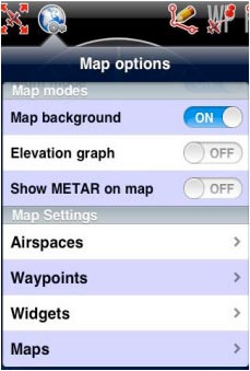
From the «Toolbar» press the «Map Options» button to access various options for the moving map:

- Brightness. Controls the brightness of the screen.
- Show maps. Enables or disables the screen background.
- Elevation graph. Enables or disables the terrain elevation
view.
- Terrain awareness 2D/3D. Enables or disables the terrain
awareness for both moving map and 3D EFIS module.
- Show METAR on map. Displays icons over the Airports
according to the weather conditions (VMC/IMC) on the map. Internet connection is needed to use this feature.
The «Maps settings» module
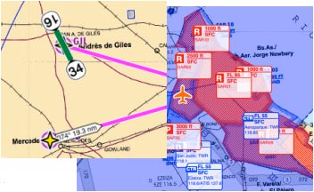
- Airspaces. Displays a list where you can show/hide the airspaces according to their type on the moving map. Use it as a filter of which type of airspaces you’d like to always see on the map and which ones not. There`s also an Altitude filter, so you might choose from seeing all the existing airspaces in the zone you are flying or just the ones at your current altitude.
- Besides, you can fully-shade the airspaces and even display their names and show them in the Elevation Graph as shown on the screenshots, below.

- Waypoints. You can filter the waypoints according to their type (Airfield, Heliport, IFR,VRP, Navaid, etc). There`s also the chance to filter by runway length and surface type.
- Obstacles.

- Widgets. You can choose to show or hide the extended track line of the plane (shown as a dotted orange line) and the bearing line to a next waypoint (shown as a dotted gray line. See
screenshot on following page. You can also show labels on each leg vector that will show distance and course to next waypoint. As another feature, Runway identifiers will extend the runway limits on the moving map to make the approach easier.
