Difference between revisions of "Translations:Introduction of the Moving Map/6/en"
Jump to navigation
Jump to search
(Importing a new version from external source) |
(Importing a new version from external source) |
||
| Line 1: | Line 1: | ||
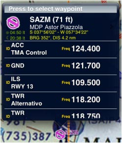
Touching an area of interest on the map will reveal a popup with useful information. Touchable items are: | Touching an area of interest on the map will reveal a popup with useful information. Touchable items are: | ||
[[File:first.jpg|frame|border]] | [[File:first.jpg|frame|border]] | ||
| − | * '''Waypoints''': elevation, type, full name for Navaids and their frequency, Airports runway and frequency information. We also | + | * '''Waypoints''': elevation, type, full name for Navaids and their frequency, Airports runway and frequency information. We also included: Sunrise/Sunset time and Bearing/Distance from current position. |
| − | included: | ||
* '''Airspace''': lower and upper limits, name, class and additional information. | * '''Airspace''': lower and upper limits, name, class and additional information. | ||
* '''METAR/TAF stations''': Weather information of an Airport. You enable them in the «Map Otions» menu. | * '''METAR/TAF stations''': Weather information of an Airport. You enable them in the «Map Otions» menu. | ||
Revision as of 19:38, 14 October 2015
Touching an area of interest on the map will reveal a popup with useful information. Touchable items are:

- Waypoints: elevation, type, full name for Navaids and their frequency, Airports runway and frequency information. We also included: Sunrise/Sunset time and Bearing/Distance from current position.
- Airspace: lower and upper limits, name, class and additional information.
- METAR/TAF stations: Weather information of an Airport. You enable them in the «Map Otions» menu.
